
Arkansas, Tennessee and Mississippi Monday Outbreak Grows More Dangerous as 3,000+ CAPE and 50-Knot Low-Level Winds Collide
LITTLE ROCK, Arkansas — Every new data update is making Monday, April 27 look more alarming for Arkansas, Tennessee, and Mississippi. A perfect atmospheric storm is assembling over the Mid-South and Ohio Valley — surface instability values surging past 3,000 to 6,000 joules per kilogram, low-level winds screaming at 40 to 50 knots, and a textbook upper-level trough positioned to maximize tornado-producing wind shear across the entire region. Confidence in a significant severe weather outbreak is no longer guarded — it is steadily increasing with every model run.
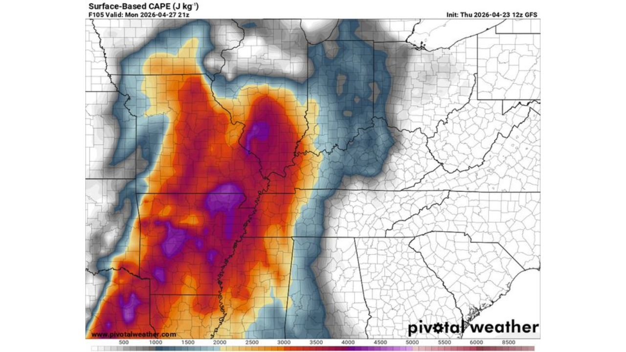
Little Rock sits directly inside the bull’s-eye of the highest instability on the map — purple CAPE values exceeding 4,000–6,000 J/kg covering central and southern Arkansas through northern Mississippi and western Tennessee.
States and Cities in Monday’s Outbreak Zone
- Arkansas: Little Rock, Jonesboro, Fort Smith, Pine Bluff, Texarkana — sitting inside the deepest instability on the entire map; purple CAPE zone centered here
- Tennessee: Memphis, Jackson — western Tennessee inside the high-instability and high-shear overlap zone
- Mississippi: Tupelo, Corinth, Oxford, Grenada — northern Mississippi pulled into the core outbreak area
- Missouri: Sikeston, Cape Girardeau, Bootheel region — inside the 500mb trough exit region where tornado threat peaks
- Illinois: Southern Illinois including Carbondale, Marion — northern fringe of the significant severe weather zone
- Kentucky: Paducah, western counties — caught in the low-level jet corridor with 40–50 knot winds
Primary Threats
- Surface CAPE exceeding 3,000–6,000 J/kg across Arkansas and the Mid-South — this is extraordinary instability for late April; the purple shading covering Little Rock through Memphis represents some of the highest storm energy values of the entire season
- 850mb low-level winds at 40–50 knots — the deep red and purple shading on the low-level wind map covering Arkansas, Tennessee, and Missouri confirms a powerful low-level jet that provides the rotational energy tornadoes need near the ground
- 500mb trough exit region perfectly positioned — the upper-level pattern shows the trough’s exit zone directly over the Mid-South, the precise location where atmospheric lifting and wind shear are maximized for tornado production
- Very high moisture return — dewpoint map shows a deep moisture surge pushing north across Arkansas and Mississippi, feeding the instability pool directly
- A severe weather outbreak — not just isolated storms but a widespread, organized event covering multiple states simultaneously
Why This Matters for Arkansas and Tennessee
The maps for Monday at 9 PM are telling a very specific and very serious story. Start with the CAPE map — the surface instability chart. The deep purple coloring centered over Little Rock and spreading across Arkansas into Mississippi represents 4,000 to 6,000+ joules per kilogram of storm energy. For comparison, a value of 1,000 J/kg is considered sufficient for severe thunderstorms. Values above 2,500 support violent storms. What is mapped over Arkansas on Monday evening is in a category that only appears a handful of times each year — and when it does, it tends to produce the kind of severe weather days that make the history books.
Now layer the 850mb wind map on top. The deep red shading covering Arkansas, Tennessee, and Missouri shows low-level winds at 40 to 50 knots — a screaming low-level jet that wraps moisture north while simultaneously cranking the wind shear values that make thunderstorms rotate. This low-level jet is the direct engine of tornado production. The stronger it is, the more violently storms can spin near the ground.
Finally, the 500mb trough is positioned with its exit region — the area of maximum upper-level divergence and atmospheric lifting — sitting directly over the Mid-South. This is the trigger that releases all that stored instability at once. The trough exit region is where the atmosphere essentially lifts the cap and allows everything below to explode upward into severe thunderstorms simultaneously across a wide area.
All three ingredients — extraordinary instability, powerful low-level jet, and a perfectly positioned upper trough — are overlapping over Arkansas, Tennessee, and Mississippi at the same time on Monday evening. That is what a severe weather outbreak looks like before it happens.
Multi-Day Pattern
Monday does not arrive in isolation. Thursday and Friday are already bringing severe weather to Oklahoma and Kansas, and Saturday brings the hail threat to the Southern Plains. The atmosphere gets a brief overnight rest before Monday’s setup assembles — but it is barely a pause. After Monday’s outbreak pushes east, the pattern continues loading for another significant event around Thursday, May 1 targeting Mississippi, Alabama, and Louisiana.
The Mid-South is entering the most active and dangerous stretch of the spring season. Monday, April 27 currently stands as the peak threat day of this entire multi-week pattern.
What to Watch Next
- CAPE values above 3,000 J/kg at storm time means any supercell that develops Monday evening will have nearly unlimited vertical energy to draw from — storms will be tall, intense, and long-lived
- Low-level jet positioning will be the final key — watch Sunday updates for the 40–50 knot wind corridor to sharpen and confirm the tornado threat zone
- Arkansas residents from Little Rock north through Jonesboro are in the highest-risk zone based on current data — treat Monday as an outbreak day, not a storm day
- Nighttime severe weather is likely for Mississippi and Alabama as storms push east after dark — the most dangerous scenario for tornado fatalities
- Formal risk categories are expected to increase in Sunday and Monday morning outlooks — watch for upgraded designations covering this corridor
Residents across Arkansas, Tennessee, and Mississippi should spend this weekend getting completely prepared — Monday, April 27 has the atmospheric fingerprint of a historic severe weather day.
WaldronNews.com will continue tracking Monday’s developing outbreak and provide updates every few hours as the forecast sharpens through the weekend.