
Ohio, Indiana and Tennessee Face 5 to 7 Degree Below-Normal Temperatures and Last Frost Risk of the Season From April 30 Through May 7
INDIANAPOLIS, Indiana — A prolonged cold stretch is arriving just as May begins, and farmers, gardeners, and anyone who has already put plants in the ground across Ohio, Indiana, Tennessee, and the broader Midwest need to pay close attention. Temperatures are forecast to run 5 to 7 degrees below normal from April 30 through May 7, with frost concerns spreading across a wide swath of the country from the Northern Plains through the Ohio Valley and into the Mid-South. For many locations, this could be the last frost risk of the season — but for those further north, the risk continues well beyond this period.
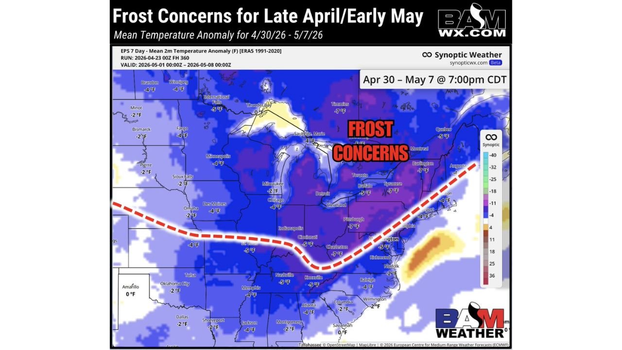
The red dashed line on the map marks the frost concern boundary — everything north of that line through early May is under active frost threat during morning hours.
States Facing Frost Concerns and Below-Normal Temps
- Indiana: Indianapolis, -5°F anomaly — well inside the frost concern zone; one of the harder-hit states in the region
- Ohio: Cincinnati, -5°F; Cleveland, -5°F; Pittsburgh area, -7°F — persistent below-normal temps through the entire period
- Tennessee: Nashville, -5°F; Knoxville, -5°F; Memphis, -4°F — southern end of the frost concern zone; could mark the last frost risk of the season here
- Illinois: Chicago, -4°F; Springfield area — inside the frost zone through early May
- Kentucky: Louisville corridor — sitting between the -5°F zones of Indiana and Tennessee
- Michigan: Detroit, -4°F — frost risk continues into May for northern portions
- North Carolina: Charlotte, -4°F; Raleigh, -4°F — surprisingly deep cold reaching into the Piedmont
- Virginia: Washington D.C., -5°F; Richmond — cold air pushing well into the Mid-Atlantic
- Minnesota and Wisconsin: Minneapolis, -4°F; Fargo, -4°F — frost risk extends further into May for these northern states
- Georgia: Atlanta, -4°F; Montgomery, -2°F — even the Deep South running below normal through the period
Primary Threats
- Frost damage to crops and gardens — the Agricultural Belt from Indiana through Ohio and Tennessee faces real frost risk during morning hours; any sensitive plants already in the ground are vulnerable
- 5 to 7 degrees below normal sustained for a full week — this is not a one-night cold snap but a prolonged below-normal stretch that keeps morning lows dangerous day after day
- Last frost of the season for many southern locations — Tennessee, North Carolina, and Georgia may experience their final frost of 2026 during this window; northern states face continued risk beyond May 7
- Agricultural impact across the Corn Belt and Ag Belt — late-planted crops and early-season growth face setback from repeated cold mornings
Why This Matters for Indiana and Ohio
Indianapolis and the surrounding Indiana farmland sit at -5°F anomaly for the entire April 30 through May 7 period. That means every single morning during this stretch could bring temperatures cold enough to damage or kill frost-sensitive plants, newly emerged crops, and fruit tree blossoms that have already opened during the warm stretch earlier in April.
The timing is particularly cruel for farmers and gardeners. The warm days of mid-April encouraged early planting and early bloom across Ohio, Indiana, and Tennessee — and now a week-long cold plunge arrives just as those plants are most vulnerable. Frost damage at this stage of growth can set back corn and soybean emergence, destroy strawberry crops mid-bloom, and wipe out fruit tree harvests that were weeks away from setting fruit.
For Tennessee and North Carolina, this period likely represents the last frost risk of the season. Once this cold air mass clears after May 7, the pattern is expected to warm and frost risk diminishes dramatically for southern locations. That makes this week the final critical window to protect sensitive plantings — miss it, and the damage is done.
Further north in Minnesota, Wisconsin, and Michigan, the story is different. Frost risk does not end with this event — it continues deeper into May as is typical for those latitudes. The boundary marked by the red dashed line on the map runs through the Ohio Valley, and anything north of that line should plan for continued frost exposure well past this week.
Multi-Day Pattern
The cold air mass responsible for this below-normal stretch is arriving on the backside of the same large-scale pattern driving the Mid-South severe weather outbreak on Monday, April 27. As the storm system responsible for Monday’s tornadoes exits east, cold air floods south behind it — dropping temperatures sharply across the Midwest and Ohio Valley for the entire first week of May.
After May 7, the pattern is expected to shift back toward more seasonal and eventually above-normal temperatures across most of the country. But the transition will not be immediate — expect the below-normal temperatures to grip the region through at least the middle of next week before any meaningful warmup arrives.
What to Watch Next
- Cover frost-sensitive plants before April 30 — this is the start of the danger window and the first morning lows could drop to damaging levels
- Indiana and Ohio farmers should monitor morning low temperature forecasts daily through May 7 — frost advisories and freeze warnings are likely for portions of both states
- Tennessee and North Carolina gardeners — if you have tomatoes, peppers, or other warm-season plants already in the ground, bring them in or cover them through this entire period
- Watch for Frost Advisories and Freeze Warnings to be issued by mid-week for the Ohio Valley corridor
- After May 7, begin monitoring the warming pattern — the first week of May is the critical protection window, and conditions improve afterward
Residents and farmers across Indiana, Ohio, Tennessee, and the Mid-Atlantic should treat the next week as the most important cold weather protection window of the spring season.
WaldronNews.com will continue tracking frost risk and temperature anomalies through early May and provide updates as advisory headlines are issued across the region.