
Washington D.C., Maryland and Virginia Drought Jumps to Severe as BWI Sits 3.31 Inches Below Normal Since March 1
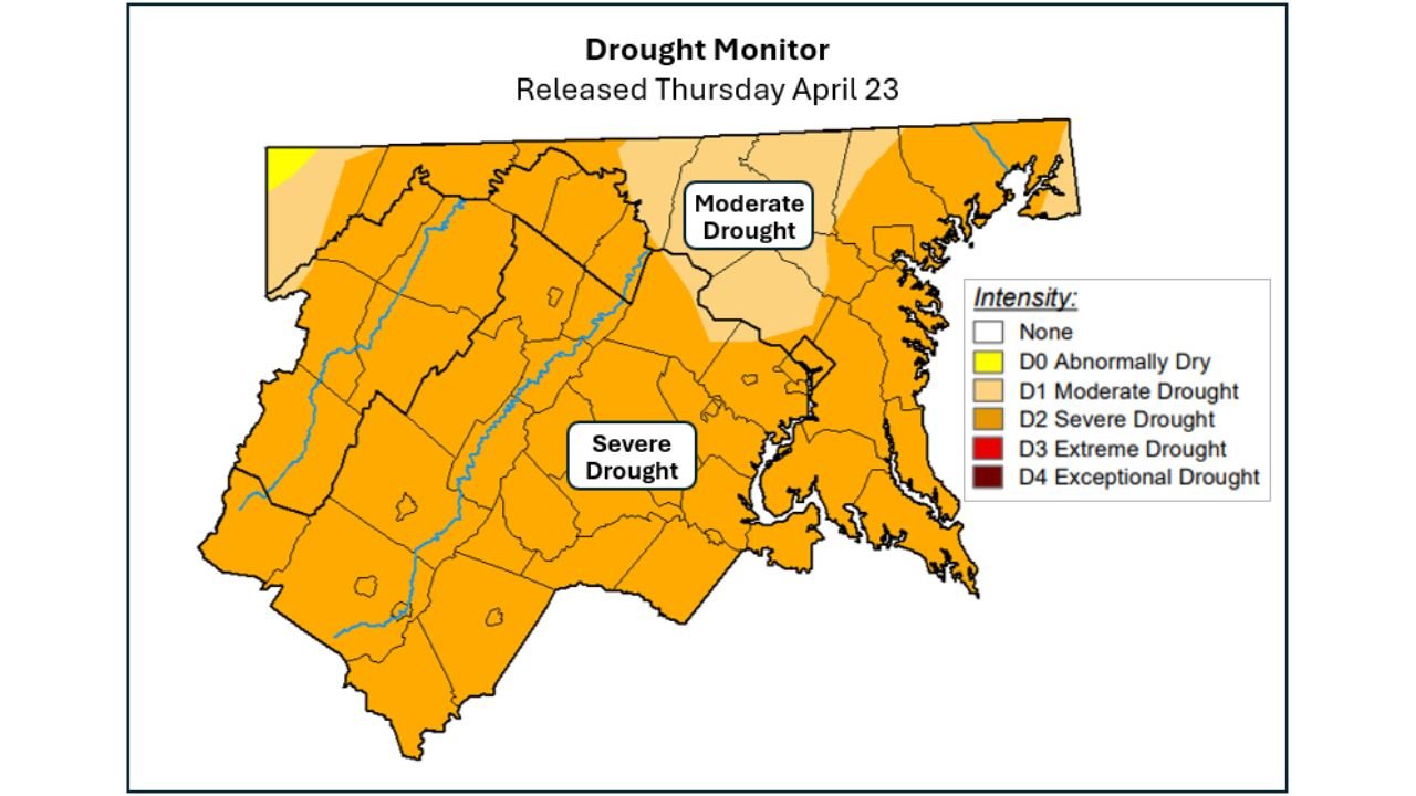
WASHINGTON, D.C. — The drought gripping the nation’s capital and surrounding region just got worse — again. The entire Beltway area and western portions of Virginia and Maryland have been upgraded to Severe Drought in the latest weekly report, one full category worse than the Moderate Drought that covered the same area just seven days ago. With BWI Airport running 3.31 inches below normal since March 1, Reagan National at 2.87 inches below normal, and Dulles at 2.18 inches below, the deficit is not a rounding error — it is a sustained, deepening water crisis with no relief in sight.
The drought is expanding northward, and no drought-busting rainfall event is currently on the horizon for Washington D.C., Maryland, or Virginia.
Cities and Areas in the Drought Zone
Severe Drought — D2 (Upgraded This Week):
- Washington D.C.: Entire Beltway area now in Severe Drought — one level worse than last week
- Virginia: Western Virginia, Shenandoah Valley, northern Virginia suburbs — all upgraded to Severe
- Maryland: Western Maryland, suburbs west of Baltimore — Severe Drought expanding eastward
- West Virginia: Eastern panhandle — inside the Severe Drought zone
Moderate Drought — D1:
- Maryland: Central Maryland including portions of Baltimore metro — still Moderate but trend is worsening
- Delaware: Northern portions — on the edge of the expanding drought footprint
- Pennsylvania: Southernmost counties along the Maryland border — drought creeping north
Primary Threats
- 3.31 inches below normal at BWI since March 1 — the largest deficit of the three major regional airports; nearly three months of accumulated dryness
- 2.87 inches below normal at Reagan National — the D.C. core is running severely short on rainfall since early spring
- 2.18 inches below normal at Dulles — western suburbs slightly better but still deeply in deficit
- Drought category jumped one full level in one week — the speed of deterioration is the most alarming part of this update; going from Moderate to Severe in seven days signals the atmosphere is providing almost no recovery moisture
- No drought-busting event on the horizon — Saturday showers and a mid-week chance next week will bring light amounts only; meaningful drought recovery requires sustained above-normal rainfall over weeks
Why This Matters for Washington D.C. and Maryland
One level of drought upgrade in a single week is a fast-moving deterioration. The D.C. region was already in Moderate Drought — a condition that stresses landscapes, reduces stream flows, and draws down reservoir levels. Jumping to Severe Drought in seven days means the ground is drying faster than the occasional light shower can compensate.
The airport rainfall data tells the story clearly. Since March 1 — nearly two full months — BWI has received 3.31 fewer inches of rain than normal. That number represents rainfall that never soaked into the soil, never recharged groundwater, and never topped off the reservoirs that Maryland and D.C. communities depend on. At Reagan National, the deficit is 2.87 inches. These are not small gaps — they represent weeks of missed precipitation stacking up month after month.
The cruel irony is that the region did pick up 0.1 to 0.2 inches of rain last week — and it still was not enough to stop the drought from worsening. That is how deep the deficit has become. Light rain events that would have been perfectly adequate in a normal spring are now being completely absorbed by dry soils without producing any measurable improvement in drought conditions.
Multi-Day Pattern
Saturday brings the best near-term chance for some additional light rainfall across D.C., Maryland, and Virginia — but totals are expected to stay light, likely in the 0.1 to 0.3 inch range for most areas. A second opportunity around the middle of next week exists but remains uncertain in both timing and coverage.
Neither event is expected to make a meaningful dent in the drought. The pattern through early May does not support the kind of multi-day, slow-moving rainfall system that would be needed to begin reversing a Severe Drought designation. Until a true soaking pattern sets up — something capable of delivering 2 or more inches over several days — the drought is likely to hold or continue expanding.
What to Watch Next
- Watch Saturday’s rainfall totals closely — even modest overperformance could slow the drought’s expansion for another week
- Baltimore and central Maryland are at risk of their own upgrade from Moderate to Severe if next week’s rain chances underperform
- Northern Virginia and the Shenandoah Valley are already in Severe Drought — any additional dry days accelerate the path toward Extreme
- Monitor the mid-May pattern for any signal of a sustained wet stretch — that is the earliest realistic window for meaningful drought improvement
- Water use restrictions from D.C., Montgomery County, and Fairfax County utilities become increasingly likely if Severe Drought persists through May
Residents across Washington D.C., Maryland, and Virginia should take this drought seriously — what started as a dry April has now become a Severe Drought expanding by the week with no quick fix on the forecast map.
WaldronNews.com will continue tracking drought conditions across the Mid-Atlantic and provide updates as the weekly Drought Monitor reports are released.