
Wednesday Front Brings Best Shot at Rain Since Last Summer as Severe Drought Region Eyes 0.5 to 1.0 Inches
WASHINGTON, D.C. — Rain has been hard to come by across the Mid-Atlantic since last summer, and this month’s precipitation has run about half of normal — roughly 1.25 inches below average — while severe drought has taken hold across much of the region. Wednesday offers the best opportunity to dent that deficit before April closes, as a strong front sweeps across the area bringing showers possible at any hour and the best rain chances concentrated in the afternoon and evening. Some heavy thunderstorms are possible, particularly across the southern part of the region, where a Level 1 out of 5 Marginal Risk for severe storms has been issued.
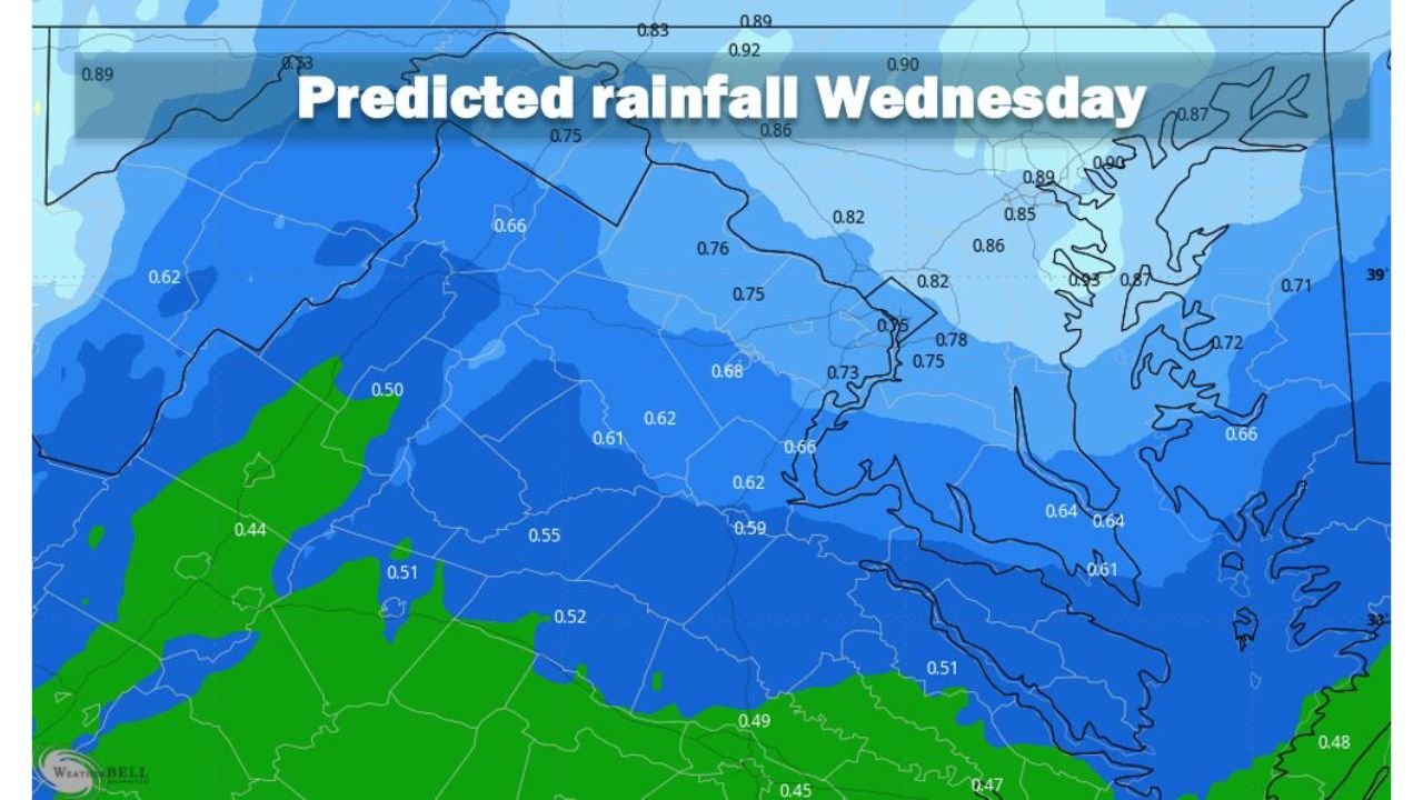
What the Predicted Rainfall Map Shows
The predicted rainfall map for Wednesday shows a broad precipitation footprint across the Mid-Atlantic, with totals varying noticeably from north to south and inland to coast:
- Northern Maryland and Delaware corridor — 0.85 to 0.92 inches, among the highest totals on the map
- Washington D.C. metro area — 0.75 to 0.86 inches across the immediate metro, with some locations approaching 0.90 inches
- Central Virginia — 0.62 to 0.82 inches across the Piedmont and central counties
- Eastern Shore and Chesapeake Bay region — 0.82 to 0.95 inches in isolated higher-end pockets near the coast
- Southern Virginia — 0.47 to 0.62 inches, lighter totals on the southern fringe of the main rainfall corridor
- Western Maryland and Pennsylvania border — 0.50 to 0.66 inches
The overall range of 0.5 to 1.0 inches represents a meaningful contribution to a region that has been running significantly below normal since last summer — but it will not close the drought gap on its own. Forecasters note that both the rainfall totals and thunderstorm intensity will need refinement over the next two days as the front’s exact timing and strength come into clearer focus.
The Drought Context — Why Wednesday Matters
The combination of below-half precipitation this month and severe drought covering much of the region makes Wednesday’s system more consequential than a typical spring rain event. Severe drought — classified as D2 on the U.S. Drought Monitor scale — means:
- Stream and river flows are running significantly below normal, stressing water supply systems and aquatic ecosystems
- Soil moisture deficits measured in inches are limiting spring vegetation green-up and stressing pastures and crops across Virginia, Maryland and surrounding states
- Wildfire risk during dry and windy periods remains elevated across the region
A single rain event of 0.5 to 1.0 inches does not end a severe drought. It does provide temporary relief to stressed soils and vegetation, partially recharges shallow groundwater and reduces the immediate wildfire risk window following the event. The April deficit of 1.25 inches below average means even a full-inch Wednesday rain would only partially offset this month’s shortfall.
The Severe Weather Component
The Level 1 Marginal Risk for severe storms applies to the southern portion of the region, where instability ahead of the front will be greatest during the afternoon and evening hours. At the Marginal Risk level, isolated severe storms are possible but not widespread or organized. The primary hazards with any storms that do reach severe criteria would be:
- Damaging wind gusts — the most common severe hazard with frontal convection in spring
- Heavy rainfall rates — embedded within stronger storm cells, capable of brief localized flooding in low-lying areas
- Small hail — possible with the stronger convective cells, particularly in the southern portion of the risk zone
The Marginal designation means residents should be weather-aware Wednesday afternoon and evening but this is not a shelter-now level threat. Staying informed and having alerts active is the appropriate response at this risk level.
Timing — When to Expect Rain Wednesday
- Morning and midday — showers possible at any time as moisture increases ahead of the front
- Afternoon and evening — the best and most organized rain window, coinciding with frontal passage and peak daytime instability
- Evening — heaviest rainfall and any thunderstorm activity most likely across the southern portion of the region
- Overnight — rain tapering as the front pushes through and drier air follows
What to Watch Over the Next Two Days
- Forecast updates through Tuesday will refine both the rainfall totals and the thunderstorm intensity — the current 0.5 to 1.0 inch range could shift upward if the front slows or downward if it moves faster than expected
- The southern portion of the region carries the higher end of both rainfall and severe storm potential — residents from southern Virginia southward should watch for updated severe weather outlooks as the front’s characteristics become clearer
- Even in a drought, flash flooding is possible when heavy thunderstorms drop 0.5 to 1.0 inches in a short window over saturated or compacted soils — do not assume drought conditions eliminate flood risk
WaldronNews.com will continue tracking Wednesday’s frontal system across the Mid-Atlantic and provide updates on rainfall totals, thunderstorm potential and drought impact as the forecast evolves.