
Tornado Threat Shifts to the Delta Tonight as Dryline Fires Into Central Missouri and Arkansas
MEMPHIS, Tennessee — The main severe weather event is now getting underway across the central United States, and the picture is evolving exactly as forecasters anticipated — messy and disorganized on the north side, capped but promising to the south. The afternoon hours are being led by hailstorms across the region, with the more significant tornado threat expected to shift toward the Delta region of central and southern Missouri and Arkansas this evening and overnight as dryline convection fires and shear vectors come into alignment.
Why the North Side Is Messy
The northern portion of today’s severe weather corridor is behaving as forecast models suggested it would. Strong divergence aloft combined with line-parallel shear is producing a disorganized, messy storm evolution across the northern risk zone. Line-parallel shear — where the wind shear vector runs parallel to the storm line rather than perpendicular to it — limits the ability of individual storm cells to develop sustained rotation. Without rotation, supercell structure breaks down and the tornado threat is substantially reduced even in an otherwise unstable environment.
The 300mb analysis valid April 27 at 2138Z confirms the upper-level dynamics at work. The orange ellipse on the map marks the right exit region of the jet streak across the southern portion of the risk area, where divergence aloft is present but organized differently than in the northern corridor. The jet streak’s orientation and the divergence pattern visible in the magenta contours explain the split character of today’s event — active and disorganized to the north, capped but increasingly promising to the south.
The Southern Setup — Capped Now, Threatening Tonight
Further south across central and southern Missouri and Arkansas, the atmosphere has been kept mostly capped through the afternoon hours by the right exit region of the jet suppressing upward motion. A cap — a layer of warm air aloft that prevents surface-based parcels from rising freely — is acting as a temporary lid on convection across this corridor.
The key development is that shear vectors across the dryline look promising. The dryline — the boundary between dry air pushing east from the Plains and moist Gulf air to the east — is the focal point where storm initiation is most likely once the cap erodes. When convection does fire into central and southern Missouri and Arkansas this evening, it will do so into an environment where the shear profile supports organized, rotating supercells rather than the messy line convection dominating the north.
Forecasters are explicit: once that convection fires, the tornado threat may become more realized this evening and overnight near the Delta region. The Delta — the low-lying agricultural corridor along the Mississippi River through Arkansas, Mississippi and Tennessee — is the geographic target for the overnight tornado window.
What the MLCAPE and Shear Analysis Shows
The SPC 0-3 km MLCAPE and bulk shear analysis valid April 27 at 2100Z shows the instability and shear environment across the active region. MLCAPE — Mixed Layer Convective Available Potential Energy, a measure of atmospheric instability that accounts for a layer of air near the surface rather than just the surface itself — shows red contours with values at 150 to 180+ J/kg across the southern Missouri and Arkansas corridor, with the dashed black line marking the approximate position of the warm front boundary separating the stable air to the north from the more unstable environment to the south.
The bulk shear values across the southern corridor are oriented in a direction favorable for supercell development rather than line convection, consistent with the assessment that discrete rotating storms are possible once initiation occurs along the dryline.
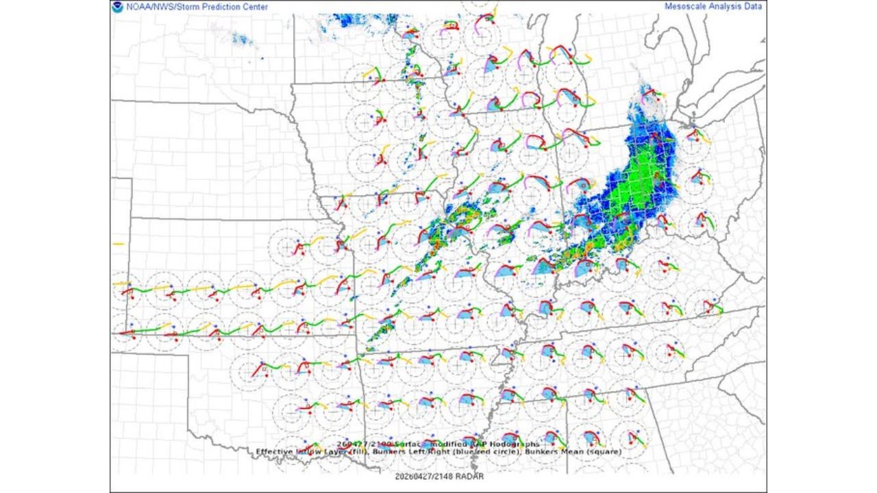
The Hodograph Picture — Why Tonight’s Southern Storms Carry Tornado Potential
The SPC surface-modified RAP hodograph analysis valid April 27 at 2100Z shows the wind profile across the entire region. The hodograph shapes visible across the southern Missouri, Arkansas and Delta corridor display significantly more curvature and length than those to the north, where straight or weakly curved hodographs are consistent with the hail-dominant, tornado-limited character of today’s afternoon storms.
Straight hodographs explain the afternoon storm mode clearly. When the hodograph is relatively straight rather than curved, the wind shear favors straight-line wind and hail production over tornado development. Storms in a straight hodograph environment tend to be undercut by their own outflow or fail to develop sustained mesocyclones — which is why today’s daytime activity has been mostly hailstorms due to either being undercut or straight hodographs.
The more curved hodographs developing across the southern corridor as the evening progresses indicate increasing streamwise vorticity — the rotational energy that supercell updrafts can tilt into a vertical orientation to produce a mesocyclone and ultimately a tornado.
The Delta Tornado Window — Evening Into Overnight
Three factors are converging to make the Delta region the focus for tonight’s tornado threat:
- Dryline convection firing into southern Missouri and Arkansas as the cap erodes through the evening
- Shear vectors becoming favorable for discrete supercell development along and east of the dryline
- Hodograph curvature increasing across the Delta corridor as the low-level jet strengthens overnight
The overnight low-level jet — a nocturnal strengthening of southerly winds in the lowest levels of the atmosphere that commonly occurs across the central United States after sunset — is the key ingredient tonight. As it strengthens, it will increase low-level wind shear across Arkansas, Mississippi and Tennessee, enhancing tornado potential for any supercells that remain active into the overnight hours.
Cities and Areas to Watch Tonight
Evening dryline initiation zone:
- Springfield, Missouri
- Joplin, Missouri
- Fayetteville, Arkansas
- Fort Smith, Arkansas
- Jonesboro, Arkansas
Overnight Delta tornado window:
- Little Rock, Arkansas
- Memphis, Tennessee
- Tupelo, Mississippi
- Jackson, Mississippi
- Greenville, Mississippi
- Greenwood, Mississippi
What to Watch Through This Evening
- Dryline convection initiation across central Missouri and Arkansas is the trigger — once storms fire along or east of the dryline after sunset, the tornado threat window opens for the Delta region
- Low-level jet strengthening after 9 PM local time will signal that hodograph curvature is increasing and tornado potential is rising across Arkansas and Mississippi
- Residents across the Delta region should not assume the threat has passed because afternoon storms were hail-dominated — tonight’s storm mode will be fundamentally different once discrete supercells fire into the favorable southern shear environment
- Keep overnight weather alerts active — this is an evening and overnight threat, not an afternoon event
WaldronNews.com will continue tracking tonight’s evolving tornado threat across the Delta region and provide updates on dryline convection, tornado warnings and storm reports through the overnight hours.