
Winter-Like Cold Pattern Takes Hold Through Early May as Deep Jet Stream Dip Sends Canadian Air Across the Eastern Half of the United States
WASHINGTON, D.C. — A cooler-than-normal weather pattern is taking root across the eastern half of the United States and looks durable through the first seven to ten days of May. The longer-range models describing this setup are not using spring language — they are describing a pattern with a distinctly winter appearance, featuring a large and persistent dip in the jet stream centered over the Great Lakes region with blocking high pressure anchored to the north over Canada and toward Greenland. The result is a sustained funnel of chilly air from the Canadian prairies pushing south and southeastward to cover much of the eastern Lower 48 through early May.
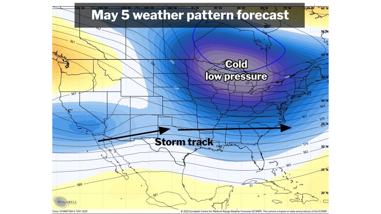
What the May 5 Pattern Looks Like
The ECMWF weather pattern forecast for May 5 shows the atmospheric configuration driving this cold outbreak with clarity. A deep cold low pressure system is centered over the Great Lakes and Upper Midwest, indicated by the tightly packed blue contour lines and the 546 decameter height value at the core — a reading more consistent with January than May across this region. High pressure to the north over Canada and Greenland acts as a blocking feature, preventing the jet stream from lifting northward and locking the cold trough in place over the eastern half of the country.
The storm track arrow on the May 5 forecast runs along a strikingly southern path — from the Pacific Coast through the southern tier of the United States toward the Gulf Coast. This is the key signal for what kind of May the eastern United States is heading into. With cold air dominating the interior, storm systems will be forced to track well south of their typical May path, keeping the active weather closer to the Gulf Coast region rather than the Ohio Valley and Mid-Atlantic where May storm tracks normally run. Whether this produces a stormy pattern for Washington D.C. and the Mid-Atlantic remains uncertain — the storm track’s exact position south of normal is still being resolved in the modeling.
Temperatures Versus Normal on Sunday — The Cold Is Already Here
The temperatures versus normal map for Sunday shows the cold pattern already in place and well-established across the eastern half of the country. The coverage of below-normal temperatures is broad and deep:
- The entire Great Lakes region, Midwest, Ohio Valley, Mid-Atlantic and Northeast are running cooler than normal — shown in green shading extending from the Upper Midwest through New England and down the East Coast
- Texas, New Mexico and the southern Plains show the most intense cold anomaly on the map — deep green shading transitioning to blue and purple over west Texas and New Mexico, indicating the coldest departures from normal on the entire map for this time of year
- The West Coast and Pacific Northwest stand in sharp contrast, running warmer than normal under the high pressure ridge on the western side of the pattern
- Canada’s eastern provinces show near-normal to slightly below-normal temperatures, consistent with the source region for the air mass pushing south into the United States
Why This Pattern Has a Winter Appearance
The specific combination of features forecasters are describing — a deep Great Lakes trough, Greenland blocking and Canadian high pressure — is a pattern configuration that meteorologists associate with winter cold outbreaks rather than spring warmth. In winter, this setup produces Arctic air invasions. In late April and early May, it produces:
- Temperatures running 5 to 15 degrees below normal across the affected regions
- Frost and freeze risk for gardens, orchards and early-season crops across the Mid-Atlantic, Ohio Valley and southern Appalachians where vegetation has already responded aggressively to the warm March and April
- A storm track displaced south toward the Gulf Coast, meaning the typical May severe weather corridor through the Plains and Midwest may be suppressed while the Gulf Coast and Southeast see more active weather than normal
- Prolonged duration — the blocking pattern over Greenland and Canada tends to be self-reinforcing, making it resistant to pattern changes once established. The seven to ten day duration estimate reflects how stable these blocking configurations typically are once they lock in
The Storm Track Shift and What It Means
The southward displacement of the storm track is one of the most consequential aspects of this pattern for the broader region. A normal May storm track through the Ohio Valley and Mid-Atlantic supports the typical spring severe weather season across the central and eastern United States. When the track drops toward the Gulf Coast:
- Gulf Coast states — Louisiana, Mississippi, Alabama, Georgia and Florida — face an elevated storm and rainfall threat through the period
- Washington D.C. and the Mid-Atlantic face uncertainty — the storm track’s exact position determines whether the region sees active weather or stays largely dry under the cold high pressure
- The Ohio Valley and Great Lakes sit under the cold trough itself, keeping temperatures suppressed but potentially limiting organized storm development compared to a more typical May pattern
What to Expect Through Early May
- Below-normal temperatures across the Mid-Atlantic, Northeast, Ohio Valley, Great Lakes and Midwest through at least May 6 to May 10
- Frost risk for elevated and inland areas of Virginia, West Virginia, Pennsylvania and New England on the coldest nights within this pattern
- Storm activity favoring the Gulf Coast rather than the traditional May storm corridor through the central United States
- The West Coast warmth visible on the Sunday temperature map will persist as the ridge-trough pattern maintains itself with warm air on the western side and cold air on the eastern side of the continent
- Pattern change signals beyond May 10 remain uncertain — the durability of Greenland blocking makes extended forecasting difficult, and any weakening of that block would be the first signal that the cold pattern is breaking down
WaldronNews.com will continue tracking the early May cold pattern across the eastern United States and provide updates on frost risk, storm track evolution and temperature trend changes as the pattern develops through the first week of May.