
Dallas-Fort Worth MetroPlex Faces Isolated Softball-Sized Hail and Tornado Risk Today as Splitting Supercells Expected to Develop Along Stalled Front Between 3 and 5 PM
DALLAS, Texas — Tuesday, April 28 brings a significant hailstorm threat to the Dallas-Fort Worth MetroPlex and the Interstate 30 corridor, with storms expected to rapidly develop during the evening commute window between 3 and 5 PM. The headline threat is large and potentially historic hail — isolated stones reaching baseball to softball size are possible where rotating supercells establish themselves. A tornado or two cannot be ruled out either, particularly from any right-split supercells that drift south of the MetroPlex through the afternoon.
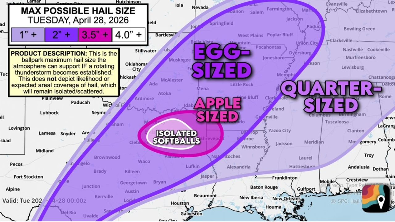
The Maximum Possible Hail Size Map — What Each Zone Faces
The Max Possible Hail Size forecast valid Tuesday April 28 shows the maximum hail potential if a rotating thunderstorm becomes established across each zone. This map does not show likelihood or areal coverage — it shows the ceiling of what is possible where hail does occur:
- Isolated Softballs (4.0+ inches) — the innermost zone, centered directly over the DFW MetroPlex and the surrounding area along Interstate 20 and Interstate 30. Softball-sized hail at 4 inches or larger causes catastrophic damage to vehicles, roofs, skylights and any exposed property
- Egg-sized (3.5+ inches) — expanding outward through north Texas and into southern Oklahoma, covering the broader MetroPlex suburban ring
- Apple-sized (2.0+ inches) — the next zone outward, reaching into the Texarkana corridor and portions of Arkansas
- Quarter-sized (1.0+ inches) — the outer boundary extending through much of the region from Oklahoma through Arkansas and into Mississippi and Tennessee
Why This Setup Produces Extreme Hail
The atmospheric ingredients combining today to support softball-sized hail are specific and well-understood:
- Temperatures in the upper 80s to near 90°F at the surface, combined with Gulf humidity, create an extremely juiced-up environment with copious storm fuel — deep CAPE (Convective Available Potential Energy) that drives explosive updrafts strong enough to suspend large hailstones aloft for extended periods
- A quick temperature drop with height — steep lapse rates — means the atmosphere cools rapidly as altitude increases, which accelerates updraft development and increases hailstone growth rates
- Dry air aloft counterintuitively enhances hail production. Dry mid-levels cause supercooled water droplets to rime growing hailstones with additional layers of ice, building stones to larger sizes before they fall. This is a key factor in why splitting supercells in environments like today’s can produce baseball and softball-sized stones
- A stalled frontal boundary near Interstate 20 and Interstate 30 provides the focal mechanism for storm development — the boundary acts as a trigger that concentrates storm initiation along a defined line rather than allowing scattered, disorganized convection
The Splitting Supercell Mechanism — How the Hail and Tornado Threats Separate
Forecasters expect a couple of supercells to form near the MetroPlex by approximately 3 PM. What happens next is the key to understanding the dual hail and tornado threat today. Initial rotating supercells may split into pairs through a process where the original storm divides into two separate cells that track in different directions:
- Left splits — spin clockwise and are significant hail producers. These storms are the primary source of the softball-sized hail threat across the MetroPlex and Interstate 30 corridor
- Right splits — spin counterclockwise, drift south away from the original storm track and are the cells most capable of producing a tornado or two as they access the unstable warm sector to the south
This splitting behavior is one of the most well-documented mechanisms for producing both extreme hail and tornadoes from the same storm complex within a short time period. Splitting supercells are described by forecasters as very good at cranking out big hail — the split itself tends to intensify the updraft in both daughter cells temporarily, and a stronger updraft means larger hailstones.
The Evening Commute Problem
Storm development expected between 3 and 5 PM places the most intense hail-producing supercells directly over the MetroPlex during the peak evening commute window. This is the worst possible timing for a softball hail threat. Commuters caught on highways and surface roads during the storm passage face:
- Vehicle damage from softball-sized hail — stones at this size shatter windshields, dent hoods and roofs and can cause injury to anyone outside a vehicle
- Reduced visibility during intense hail cores, making highway driving dangerous
- No shelter access — vehicles on the highway offer minimal protection compared to a parking garage or substantial building
Forecasters are explicitly recommending that MetroPlex residents park vehicles inside a garage or beneath a carport before the afternoon storm window opens. Anyone who cannot get off the road by 3 PM should identify covered parking options along their commute route in advance.
Cities in Each Hail Zone
Isolated softball zone (4.0+ inches):
- Dallas, Texas
- Fort Worth, Texas
- Arlington, Texas
- Irving, Texas
- Garland, Texas
Egg-sized zone (3.5+ inches):
- Denton, Texas
- McKinney, Texas
- Sherman, Texas
- Wichita Falls, Texas
- Durant, Oklahoma
Apple-sized zone (2.0+ inches):
- Texarkana, Texas and Arkansas
- Tyler, Texas
- Shreveport, Louisiana
What to Do Before 3 PM Today
- Park all vehicles inside a garage or under a carport now — softball-sized hail causes total-loss vehicle damage in seconds and there will be no time to move vehicles once storms develop
- Avoid being outdoors or on the highway between 3 and 6 PM across the MetroPlex — hail at this size is a physical injury threat to anyone outside a structure
- If caught driving during the storm, pull under a highway overpass or into a covered parking structure — do not remain in an exposed parking lot
- Watch for tornado warnings south of the MetroPlex through the afternoon, as right-split supercells drifting south will be tracked closely for tornado development
- Keep weather alerts active through the entire afternoon and evening commute window
WaldronNews.com will continue tracking Tuesday’s hailstorm and tornado threat across the Dallas-Fort Worth MetroPlex and provide updates on storm development, hail reports and tornado warnings as storms evolve through the afternoon.