
Fort Worth, Weatherford and North Richland Hills Face Heavy Rain and Embedded Large Hail as HP Supercells Track Northeast Through Dallas-Fort Worth Tuesday
FORT WORTH, Texas — The supercell storms tracking through the Dallas-Fort Worth corridor Tuesday afternoon are not behaving like classic tornado producers — and the atmospheric science behind today’s setup explains exactly why. These are High Precipitation supercells, commonly called HP supercells or meteorological meatballs, characterized by extreme rainfall output with large hail cores embedded deep within the rain shield. The combination of abundant warm moisture, parallel bulk shear and strong storm-relative inflow is producing storms that are big time rain makers with hail that is difficult to see coming until it is already falling.
Why These Storms Are HP Supercells — Not Classic Hail Producers
Two specific atmospheric factors are driving the HP character of today’s storms, and both are visible in the HRRR sounding analysis valid Tuesday April 28 at 22Z for the 32.73°N, 97.09°W location near the Fort Worth corridor.
Factor One — Extreme Low-Level Moisture: The sounding shows the atmosphere is very saturated with moisture and large mixing ratios through the lowest levels. The parcel path does not reach freezing until nearly 6 km into the atmosphere — an extraordinarily high freezing level for hail production. That much warmth and lift in the lower half of the storm generates a large amount of rainfall before any precipitation reaches hail-producing temperatures. The DCAPE of 1442 and surface dewpoints near 79°F confirm the depth and richness of the moisture being ingested into these storms.
The sounding also shows very large CAPE between 0°C and -20°C — the Hail Growth Zone — with large CAPE and ice and supercooled water extending into the upper levels. This is the hail-producing layer, but it sits on top of the deep warm moisture layer below, meaning storms must first process enormous amounts of warm rain before hailstones can grow and survive long enough to reach the ground.
Factor Two — Parallel Bulk Shear: The 0-6km bulk shear vector is running parallel to the storm line rather than perpendicular to it. When bulk shear is parallel to storm motion, storms to the southwest are precipitation-loading the downstream updrafts — essentially, the rain and hail from upstream cells is falling into the inflow region of cells to the northeast, partially blocking fresh unstable air from reaching the updraft core cleanly. This precipitation loading suppresses classic supercell organization and tornado production while simultaneously producing the heavy, rain-wrapped character that defines HP supercells.
The STP (Significant Tornado Parameter) of 0.99 and SHP of 2.7 on the sounding confirm the environment is borderline for significant tornado production — not zero, but significantly reduced compared to what the instability numbers alone would suggest, precisely because of the parallel shear configuration.
What the Radar Confirms
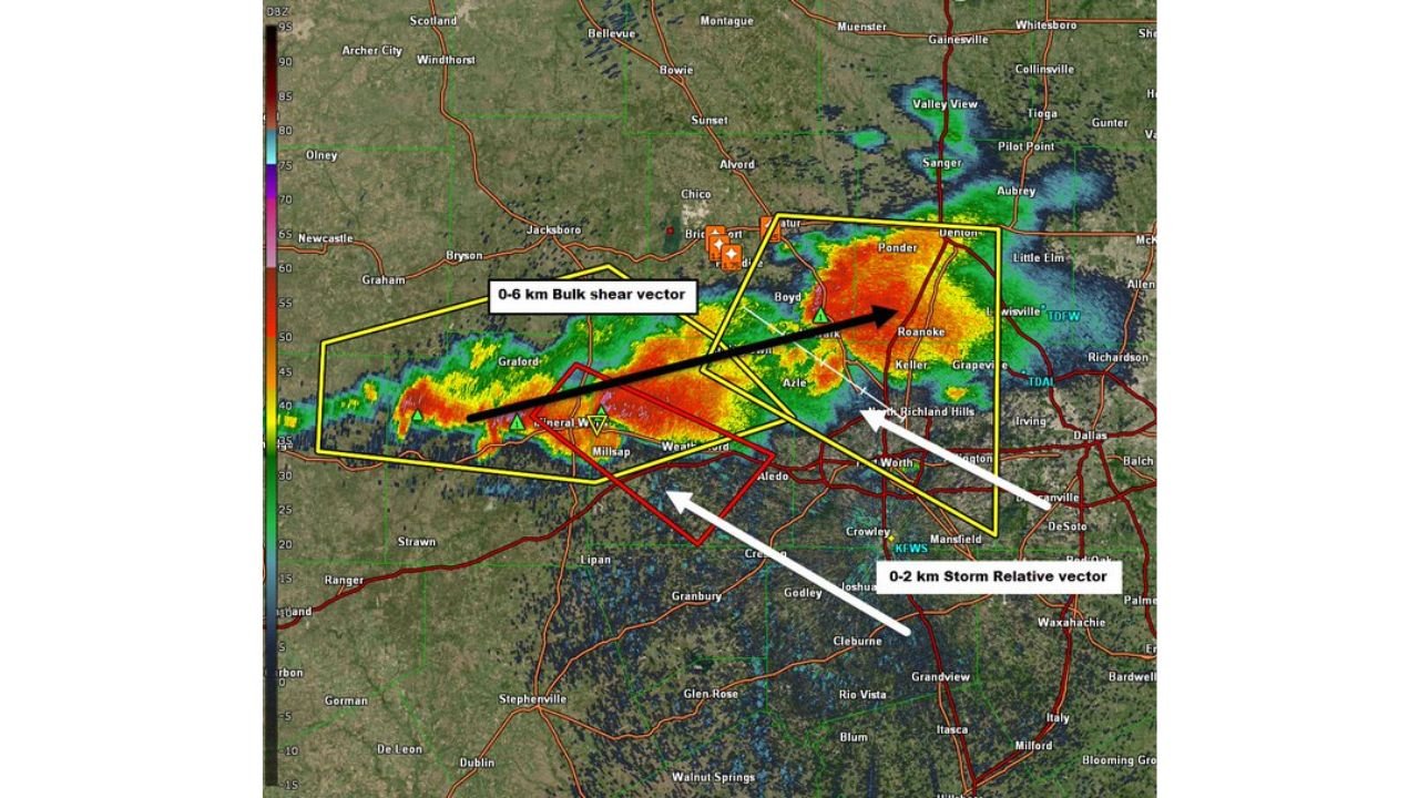
The live radar image showing the storm complex from Mineral Wells through Weatherford and into Fort Worth and Roanoke at 0Z Tuesday makes the parallel shear story visually clear. The black arrow marking the 0-6km bulk shear vector runs northeast — nearly parallel to the storm line orientation. The white arrow marking the 0-2km storm-relative inflow vector runs from the south-southeast, showing the low-level inflow direction that is sustaining the storms.
The red outlined supercell near Mineral Wells and Weatherford is the most discrete and organized cell on the radar, with the triangular markers indicating storm motion vectors tracking northeast toward Fort Worth and the western suburbs. The storm complex extends from Weatherford through Azle and into North Richland Hills and Roanoke, with the eastern edge approaching the KDFW airport corridor.
The strong storm-relative inflow visible on the hodograph — with the 0-2km SRH of 251 m²/s² — is the ingredient keeping these storms organized despite the parallel shear limitations. Strong inflow means fresh, unstable air continues to feed the updraft even as the precipitation loading works against classic supercell organization.
The Hail Threat — Large Cores Hidden in Heavy Rain
The SARS sounding analogs on the sounding output show 90% significant hail probability from the 50 loose analog matches — meaning the atmospheric profile today strongly resembles past events that produced significant hail (2 inches or larger). The embedded large hail cores in HP supercells are particularly dangerous because:
- The hail is wrapped in heavy rain, making visual detection impossible until the stone is already falling
- Radar hail signatures are partially obscured by the heavy precipitation shield surrounding the hail core
- Hail can reach the ground at golf ball to baseball size with essentially no visual warning for anyone outdoors
Cities in the Current Storm Corridor
- Mineral Wells, Texas — western anchor of the active storm complex
- Weatherford, Texas — discrete supercell tracked through this corridor
- Azle, Texas — in the path of the northeastern storm track
- Fort Worth, Texas — primary metro target as storms track northeast
- North Richland Hills, Texas — eastern suburban corridor
- Roanoke, Texas — northern DFW suburb in the storm path
- Keller, Texas — within the approaching storm envelope
What Residents Need to Do Right Now
- Move vehicles inside immediately — HP supercells drop large hail with almost no warning inside the heavy rain core. Vehicles left outside in the storm path face baseball-sized hail damage with no opportunity to relocate once the storm arrives
- Do not go outside to look for hail or photograph the storm — HP supercells are visually unimpressive because the tornado and hail are hidden inside the rain. The lack of a visible wall cloud or funnel does not mean the storm is not dangerous
- The Fort Worth western suburbs from Weatherford through Azle and into North Richland Hills face the most immediate threat as the storm complex tracks northeast
- Watch for flash flood warnings alongside hail warnings — the extreme rainfall rates from HP supercells can produce 2 to 4 inches per hour in the heaviest cores, causing rapid street and low-water crossing flooding
WaldronNews.com will continue tracking Tuesday’s HP supercell complex across the Dallas-Fort Worth MetroPlex and provide updates on hail reports, flash flood warnings and storm progression through the evening.