
North Carolina and South Carolina Drought Worsens With Only 0.8% Chance of Recovery as Charlotte Needs 12 to 14 Inches of Rain in One Month
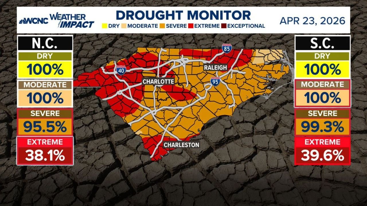
CHARLOTTE, North Carolina — The drought gripping North Carolina and South Carolina just got worse, and the numbers behind a full recovery are staggering. Charlotte would need 12 to 14 inches of rain in a single month to end the drought — and the chance of that actually happening sits at just 0.8%. Every county in both states is now classified as at least Moderate drought, 95.5% of North Carolina is in Severe drought, and 38.1% has crossed into Extreme drought territory with conditions still deteriorating.
This is no longer a drought that a few good rain weeks will fix. The math simply does not work on that short a timeline.
Cities and Counties in the Drought Zone
North Carolina — 100% of the state in drought:
- Charlotte: Extreme drought; needs 12–14 inches in one month to recover; only 0.8% chance of ending drought in 30 days
- Raleigh: Severe to Extreme; needs 10–11 inches in one month
- Asheville: Severe to Extreme; needs 14–16 inches in one month — among the highest deficits in the state
- Greenville/Spartanburg area: Needs 14–20 inches — the highest drought-ending rainfall requirement on the entire map
- Boone: Needs 10–11 inches; best recovery odds in the state at 8.1% in one month, 44.3% in three months
- Statesville: Needs 9–11 inches; 3.8% chance of ending drought in one month, 29.9% in three months
- Morganton: Needs 9–11 inches; 0.9% chance in one month, 21% in three months
- Southern Pines/Rockingham: Needs 9–10 inches — lighter deficit but still severe
South Carolina — 100% of the state in drought:
- Charleston: Extreme drought; 39.6% of the state now in Extreme category
- Rock Hill/Chester: Needs 11–13 inches to end drought in one month
- Cheraw/Lancaster: Needs 7–8 inches — lower bar but still far beyond normal monthly rainfall
Primary Drought Indicators
- North Carolina: 100% Dry, 100% Moderate, 95.5% Severe, 38.1% Extreme — and worsening
- South Carolina: 100% Dry, 100% Moderate, 99.3% Severe, 39.6% Extreme — nearly the entire state in severe or worse
- Charlotte drought-ending rainfall needed: 12–14 inches in one month — roughly 4 to 5 times the normal April monthly average
- Greenville/Spartanburg corridor: Needs 14–20 inches — the most extreme deficit zone on the map
- Boone has the best recovery odds of any city tracked — still only 44.3% in three months
Why This Matters for Charlotte and the Carolinas
The numbers are not just bad — they reveal how deeply entrenched this drought has become. Charlotte receiving 0.8% chance of drought recovery in the next month means that statistically, for every 125 years with this same atmospheric setup, the drought ends in one month only once. That is not pessimism — that is the math of how much water deficit has built up underground, in reservoirs, in soil, and in the water table across the Piedmont and Foothills of North Carolina.
The Greenville-Spartanburg corridor straddling the North Carolina-South Carolina border needs up to 20 inches of rain in one month — a figure that exceeds what most locations in this region receive in 4 to 5 months combined under normal conditions. That number alone tells you just how far behind the region has fallen.
Asheville in the western mountains needs 14 to 16 inches — a reflection of how the drought has penetrated even the typically wetter mountain counties that normally benefit from orographic rainfall. When the mountains are in Extreme drought, the entire region is in serious trouble.
The May pattern change offers some hope for additional rain chances, but forecasters are clear: there is nothing on the horizon that ends this drought in the next couple of months. The best-case scenario is a gradual improvement that slowly chips away at the deficit over summer — not a dramatic reversal.
Multi-Day Pattern
A pattern shift arriving in early May is expected to bring more consistent rain chances to the Carolinas after an almost completely dry April. However, even if May delivers above-normal rainfall — which is far from guaranteed — the deficit is so large that meaningful drought improvement would take months of sustained above-average precipitation to achieve.
The upcoming active storm pattern bringing severe weather to the Mid-South and Plains this week may clip portions of the Carolinas with some rainfall, but totals from those systems are expected to be light — adding inches when the region needs feet.
What to Watch Next
- Track May rainfall totals closely — even modest above-normal rain starts the slow process of deficit reduction
- Asheville and the Greenville-Spartanburg corridor have the deepest deficits and need the most sustained rainfall — watch soil moisture updates for these areas
- Boone is the one bright spot with the best recovery odds — mountain communities should watch for heavier rainfall events that could accelerate local improvement
- Water restriction announcements from Charlotte, Raleigh, and Charleston municipalities are increasingly likely if conditions hold
- The 3-month outlook is more meaningful than the 1-month right now — track the June–July precipitation forecasts as the true recovery window
Residents across North Carolina and South Carolina should understand that this drought is a months-long story, not a weeks-long one — and the sooner water conservation habits form, the better positioned communities will be for the dry stretch ahead.
WaldronNews.com will continue tracking drought conditions across the Carolinas and provide updates as the May rainfall pattern develops.