
Missouri and Kansas Brace for Severe Storms Today 2 PM to 5 PM as 83 Degree Heat Collides With 23 Degree Cold Near Kansas City
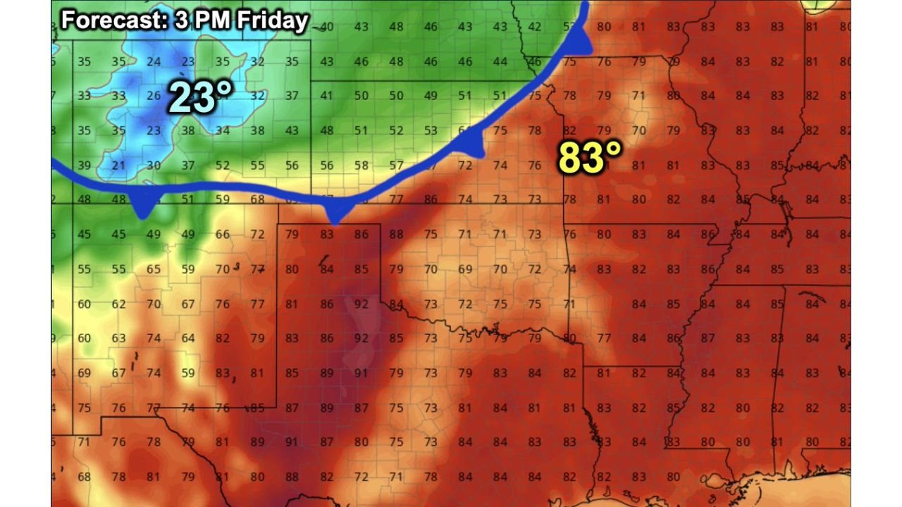
KANSAS CITY, Missouri — One of the most dramatic weather contrasts of the entire spring season is playing out right now across the Central Plains, and Kansas City sits directly at the collision point. At 3 PM Friday, temperatures are hitting 83 degrees near Kansas City while it is 23 degrees and snowing just west of Denver — and those two airmasses are about to slam into each other with violent results between 2 PM and 5 PM today.
A powerful April cold front is barreling eastward and crashing directly into a warm, deeply unstable airmass parked over Missouri and Kansas. When a 60-degree temperature difference meets in a single afternoon, every mode of severe weather becomes possible — tornadoes, large hail, damaging winds, and torrential rain all on the table for communities along and ahead of the front.
Cities and States in the Direct Path Today
- Missouri: Kansas City, Independence, Lee’s Summit, St. Joseph — sitting at the exact collision zone of the cold front and warm airmass
- Kansas: Eastern Kansas communities including Topeka, Lawrence, Overland Park — watching the front push through from the west through the afternoon
- Missouri: Columbia, Jefferson City on the eastern edge as storm activity spreads northeast through the evening
- Nebraska: Southern Nebraska watching early storm development as the front drops southward
- Iowa: Southwest Iowa communities on the northern fringe of the severe weather corridor
What a 60 Degree Temperature Crash Produces
The contrast on today’s forecast map is genuinely extraordinary and tells the whole story of why this afternoon is so dangerous.
- 23 degrees with snow just west of Denver — a full winter airmass sitting on the western side of the front
- 83 degrees near Kansas City — a warm, humid, deeply unstable summer-like airmass on the eastern side
- Temperatures crashing from 83 down to the 40s by 9 PM tonight in Kansas City — a 40-degree drop in just a few hours
- Severe thunderstorms developing between 2 PM and 5 PM along and ahead of the front — the peak heating window when instability is maximum
- All modes of severe weather possible — the shear and instability combination makes tornadoes, large hail, and damaging straight-line winds all equally likely threats this afternoon
Why Kansas City Is Ground Zero This Afternoon
Kansas City is not just close to the action today — it is sitting directly at the boundary where these two completely opposite airmasses meet. The blue line on the forecast map cuts almost exactly through the metro area at 3 PM, meaning the difference between 83-degree severe storm country and the cold air behind the front is measured in just a few miles this afternoon.
When a cold front this sharp and this fast-moving crashes into air this warm and unstable, storms do not need much time to develop. Severe thunderstorms can go from initiation to tornado-warned in under 30 minutes in an environment like this. The 2 PM to 5 PM window is when the front is pushing through the heart of the Kansas City metro — that is also the window of peak afternoon heating when the atmosphere is most explosive.
By 9 PM tonight, the front will have swept through and temperatures in Kansas City will be crashing toward the 40s. But the dangerous window this afternoon is very real and very close.
The Broader Picture Across the Plains
The temperature map at 3 PM Friday shows the full scope of what is happening across the Central Plains. From Colorado eastward through Kansas and into Missouri, the temperature gradient is among the sharpest seen this spring.
Western Kansas is sitting in the 50s and 60s as the cold air pushes in. Eastern Kansas and western Missouri are still holding in the upper 70s to low 80s. That sharp boundary — where cold slams into warm — is exactly where severe thunderstorms fire and where the most intense storm activity concentrates this afternoon.
The airmass ahead of the front across Missouri, Iowa, and into Illinois is loaded with moisture and instability. Any storm that fires along the front this afternoon has all the fuel it needs to become severe quickly and stay severe as it moves northeast.
What to Do Before 2 PM Today
- Be sheltered and weather-aware before 2 PM — the severe window opens fast this afternoon across Kansas City and eastern Kansas
- Do not plan outdoor activities this afternoon — the 2 PM to 5 PM window is when storms are expected to fire directly over the metro area
- Have tornado alerts active on your phone right now — in a setup this explosive, warnings arrive fast and response time is short
- Move vehicles to covered parking before noon — large hail is a serious threat with storms firing in this environment
- Watch the temperature crash tonight — the 40-degree drop from 83 to the 40s between afternoon and 9 PM means anyone outdoors this evening needs layers ready
- Kansas City metro commuters — the evening drive home could be directly inside the severe weather window — check conditions before leaving work today
The atmosphere over Kansas City and eastern Kansas is primed and the trigger is arriving this afternoon. Do not let the warm sunshine this morning create a false sense of security — conditions can change from calm to dangerous within minutes once the front arrives.
WaldronNews.com will continue tracking today’s severe weather threat across Missouri, Kansas and the Central Plains and provide live updates as storms develop through the afternoon and evening.